Boral’s Visual Strategy - RCKRA Project
This is one of the key changes Boral has made to maintain a green backdrop and minimise periods of visibility from surrounding residential areas. The measures that Boral has considered in the design and siting of the RCKRA Project include:

An independent visual amenity assessment was undertaken for the RCKRA Project. The assessment followed a comprehensive significance framework approach and included an assessment of impacts on the landscape as a resource, and more particular impacts on views from a range of representative receptors in the wider locality. Following field investigations and sight line modelling, a total of ten (10) representative receptor viewpoints (RRVs) were identified:
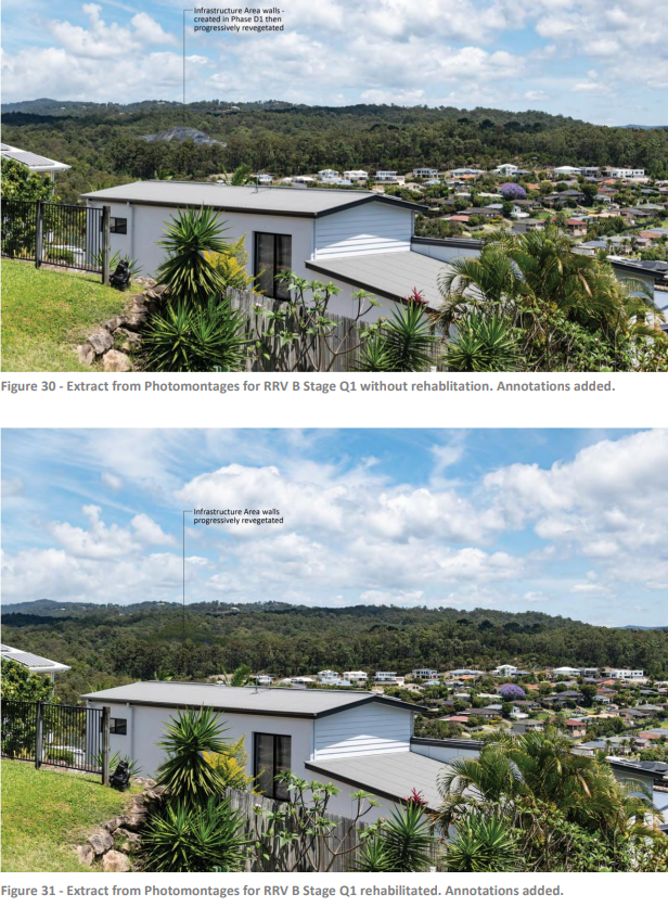
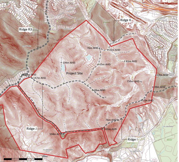
The assessment was informed by detailed Lidar-based visibility and visual exposure mapping, as well as photomontages prepared for three of the most sensitive receptors.
The visibility mapping, field investigations, and reverse visibility analysis undertaken for the RCKRA Project Landscape and Visual Assessment Report indicate:
-
There will be only narrow and fleeting views to parts of the RCKRA Project site from very limited parts of the M1, with intervening vegetation, housing, and landform, as well as roadside barriers obstructing most views from the M1;
-
Views from elevated areas west of the RCKRA Project site (such as from Chesterfield Drive) and from valley areas to the south (such as from Tallebudgera Connection Road) would only be to the tops of trees located along Ridge R3 and / or Ridge I, which will not be affected by the RCKRA Project;
-
Views from public areas and houses along the ridge to the north-east of the existing WBQ (in the vicinity of Skyline Terrace) were substantially, if not entirely, obstructed by vegetation and terrain surrounding roads and houses on this ridge system, including the more elevated terrain to the immediate north-east of the existing WBQ; and
-
While there would be visibility from the areas within the West Burleigh Industrial Precinct to the north of the RCKRA Project site, any receptors in these areas would have Low or Negligible sensitivity to changes on the RCKRA Project site.
The submitted RCKRA Project Landscape and Visual Assessment Report summarises the impacts on the ten (10) identified RRVs:
1. Of the RRVs considered, two (2) - RRV A and RRV B - would have high sensitivity. This is primarily because of the proximity of these receptors to the site, the elevation of the viewpoints in relation to the project, and the fact that the site forms part of an attractive landscape setting for these receptors.
These RRVs represent approximately 20 houses that appear to have views to the site. A number of these houses would likely experience relatively expansive views that also take in residential, commercial, and industrial development in the area, as well as the existing Council owned Reedy Creek Landfill and the existing Boral West Burleigh Quarry.
2. Five (5) of the RRVs will experience Moderate sensitivity levels, typically because they are further from the site and take in expansive views; the RCKRA Project site in this visual amenity context is less prominent. The exception is RRV C, which is the closest RRV to the site but has a Moderate sensitivity rating because views to the proposed disturbance footprint are very limited from this location.
3. The remaining RRVs have sensitivity ratings of Low, typically due to distance from the RCKRA Project site and the nature of views obtained from these viewpoints.
The measures that have already been designed into the RCKRA Project (i.e. the retention of vegetation on the land identified for environmental purposes, the incremental removal of Ridge J, the splitting of benches, and the progressive rehabilitation strategy) will all substantially mitigate visual impacts for most receptors.
The colour treatments proposed for the processing plant (as detailed on the RCKRA Project Plans) would also assist at reducing visual impacts.