

Land Use Context
Surrounding Land Use Context – What’s Around the Project Area?
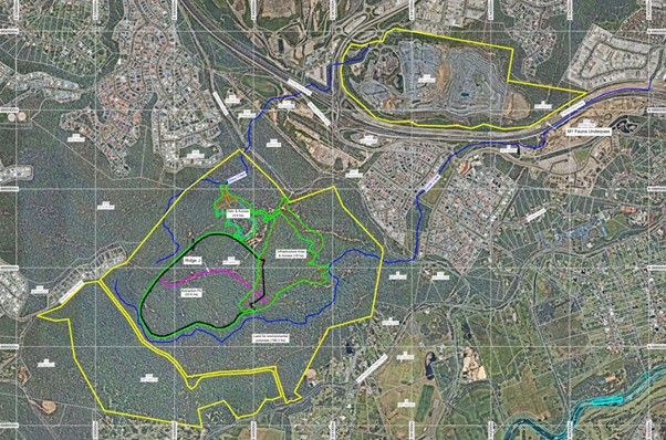
The two Project sites are separated by the M1 motorway, which at this location includes 6 moving lanes and a major interchange. East of the M1, land use is mostly industrial and commercial. To the west, there’s a mix of industrial, residential, and rural residential areas.
This location is unique because it sits at the point where land use changes—from busy urban and industrial areas to quieter rural and residential areas. Careful planning is essential to balance development with environmental protection and community needs.

The RCKRA Project Site
The RCKRA Project site is located adjacent to Old Coach Road, which acts as a transition between urban activities to the east and less intensive residential development to the west. The surrounding area includes:
-
Industrial land
To the north-east is land zoned for low-impact industry. Historically used for landfill and waste disposal, it is now undergoing rehabilitation, although resource recovery activities continue. Parts of this land have also supported the M1 upgrade works and are currently being redeveloped for a service station.
-
Residential areas
There are pockets of residential and rural residential properties near the RCKRA Project site. More intensive housing is located east of Old Coach Road in Old Burleigh Town, while to the west there is a mix of low density and rural residential development.
-
Conservation land
The RCKRA Project site adjoins land identified for open space and conservation purposes.
The WBCWRR Project Site
Although only about 500 metres east of the RCKRA Project site, the WBCWRR Project site has a distinctly different setting. It is located immediately adjacent to the M1 and the south-eastern edge of the Burleigh Heads Industrial Precinct, as well as to Council’s Reedy Creek Landfill and Resource Recovery Centre. Key features include:
-
Extractive industry zoning
The WBCWRR Project site is zoned for extractive industry and is part of a committed resource area. It is currently operating as a hard rock quarry.
-
Part of a major industrial hub
The site sits on the edge of the Burleigh Heads Industrial Precinct, one of the Gold Coast’s most significant industrial areas, accommodating a range of high-impact industrial activities. Zoning in this precinct is graduated, with low-impact industry acting as a buffer to more intensive uses.
-
Existing waste and recycling facilities
The Burleigh Heads Industrial Precinct includes several waste and recycling operations, including Council’s Reedy Creek landfill—one of only two remaining Council-owned landfills on the Gold Coast. Both facilities are expected to reach capacity within the next decade.
-
Nearby residential pockets
A small area of low-density housing is located to the north-east along Plantation Road and Dulcie Drive. Although close to industrial activities, natural topography provides vertical separation and visual relief.
Why This Matters
Understanding the surrounding land use context is an important consideration in planning assessment. This analysis shows that this locality contains a unique mix of industrial, residential, and conservation land uses around the Project sites, highlighting where careful planning is needed to balance development outcomes with environmental and community expectations.
By considering the broader land use context, both Projects have been designed to either avoid or minimise its impacts on sensitive areas. Where direct impacts remain, appropriate mitigation measures have been incorporated to ensure the development remains acceptable against all relevant regulatory controls.