

Site Baseline Conditions
Site Baseline Conditions – What’s on the Ground Today?
Before planning any development, it’s important to understand the current condition of the land. Boral has completed a range of specialist environmental studies to assess the existing values and functions of both Project sites. The findings provide a clear baseline for planning, design, and impact assessment.
Here’s what we found:
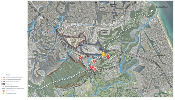
Where are the Projects Located?
-
Both sites are in the southern Gold Coast, about 500 metres apart, separated by major barriers:
-
the M1 motorway and Old Coach Road
-
a mix of low-density housing and industrial land
-
a future heavy rail corridor
-
Both Project sites fall within the Hinterland to Coast Critical Corridor (HCCC), but their contribution to this corridor is limited because of surrounding development and infrastructure -particularly the intervening public lands.
Current Landscape and History
Since the early 1970s, both sites have been significantly altered by human activity:
-
RCKRA Project site
Large-scale vegetation clearing occurred between 1971 and 1973, removing most of the original forest. Today, the site is dominated by regrowth vegetation with limited mature trees and few natural hollows for wildlife. This historic clearing has left the land vulnerable to erosion and weed invasion.
-
WBCWRR Project site
Quarrying and vegetation clearing over several decades have reshaped the land, resulting in steep slopes and areas of disturbed ground. While the WBCWRR Project site still contains some native vegetation, much of it has been impacted by historic extraction activities.
Despite past disturbance, pockets of older vegetation remain. These areas are ecologically valuable and will be retained and protected as part of the proposed development. They provide habitat for wildlife and help maintain biodiversity within an otherwise fragmented landscape.
The focus now is on restoring and enhancing the ecological function across both Project sites by:
-
Rehabilitating degraded areas.
-
Controlling invasive weeds.
-
Improving habitat quality for species like Koalas, Glossy Black Cockatoos, and Powerful Owls.
-
Reducing unauthorised access.
This history highlights why Boral’s intention is to deliver a significantly improved environmental outcome compared with the current condition of the Project sites – an outcome that would not be achievable if the proposed development does not proceed.

Vegetation and Wildlife
-
The RCKRA Project site contains predominately regrowth vegetation and habitat for:
-
Koalas (including non-juvenile koala habitat trees)
-
Glossy Black Cockatoos
-
Powerful Owls
-
Tusked Frogs
-
Rare plants such as Leichhardtia longiloba and Syzygium moorei
-
However, weed infestation is a major issue, dominating ground layers and even some canopy areas. This reduces habitat quality and makes it harder for species like koalas to move through the site.
-
The WBCWRR Project site also has native vegetation in peripheral areas, but these are under pressure from invasive weeds.
Human Impacts
-
The RCKRA Project site is currently vacant and has been subject to ongoing unauthorised public access:
-
4WD vehicles and trail bikes have caused severe erosion and damaged vegetation
-
Illegal dumping of rubbish and green waste has contributed to weed infestations
-
Dumped cars and other refuse have contaminated waterways and soil
-
These activities have created a network of eroded tracks and disturbed clearings that require substantial rehabilitation to restore the site’s environmental condition.
Waterways
-
Two main creeks run through the Project sites:
-
Stony Creek (north): Headwaters commence in RCKRA Project site is highly modified downstream - a concrete-lined drain.
-
Oyster Creek (south): Disturbance increases from west to east, with eastern sections converted into sediment ponds during M1 upgrade works.
-
Both waterways show signs of erosion, sedimentation, and weed infestation, with impacts increasing from west to east.
Why This Matters
While planning maps identify these sites as part of an important ecological corridor, the reality is that decades of disturbance have degraded their condition and functionality. Understanding these baseline conditions allows us to:
-
Target areas for rehabilitation and weed control.
-
Protect remaining habitat for wildlife.
-
Restore waterways and reduce erosion.
-
Improve the ecological value of the land into the future.
This baseline assessment provides the foundation for designing practical, effective measures that enhance the long-term environmental performance of the Project sites.